We had a mid-morning flight to Luang Prabang, so after breakfast, I had the hotel call a taxi for me to drive us to the airport. We arrived at Luang Prabang around 10AM and there were a number of flights arriving that we were at the baggage carousel for about 30 minutes. I guess Luang Prabang is the more popular destination compared to Vientiane. Good thing we didn’t have to go through immigration anymore since we were coming from Vientiane (the immigration line was seriously crazy long). Our driver was waiting for us outside to take us to our hostel, which was the Khammany Inn, located about half an hour from the Luang Prabang International Airport.

lp1

My first impression of Luang Prabang was, just like Vientiane, scorching hot during that time. The feel of Luang Prabang is somewhat different than Vientiane though. It didn’t feel like a city to me, more of a vacation getaway in the province. It has been mentioned by many bloggers and people online that Luang Prabang is definitely a must-visit place in Laos, even recommending to skip Vientiane and go to Luang Prabang instead. Luang Prabang is the former capital of Laos and is now a UNESCO World Heritage city and with all the stuff I’ve been hearing, I was very excited to explore this place.

lp2

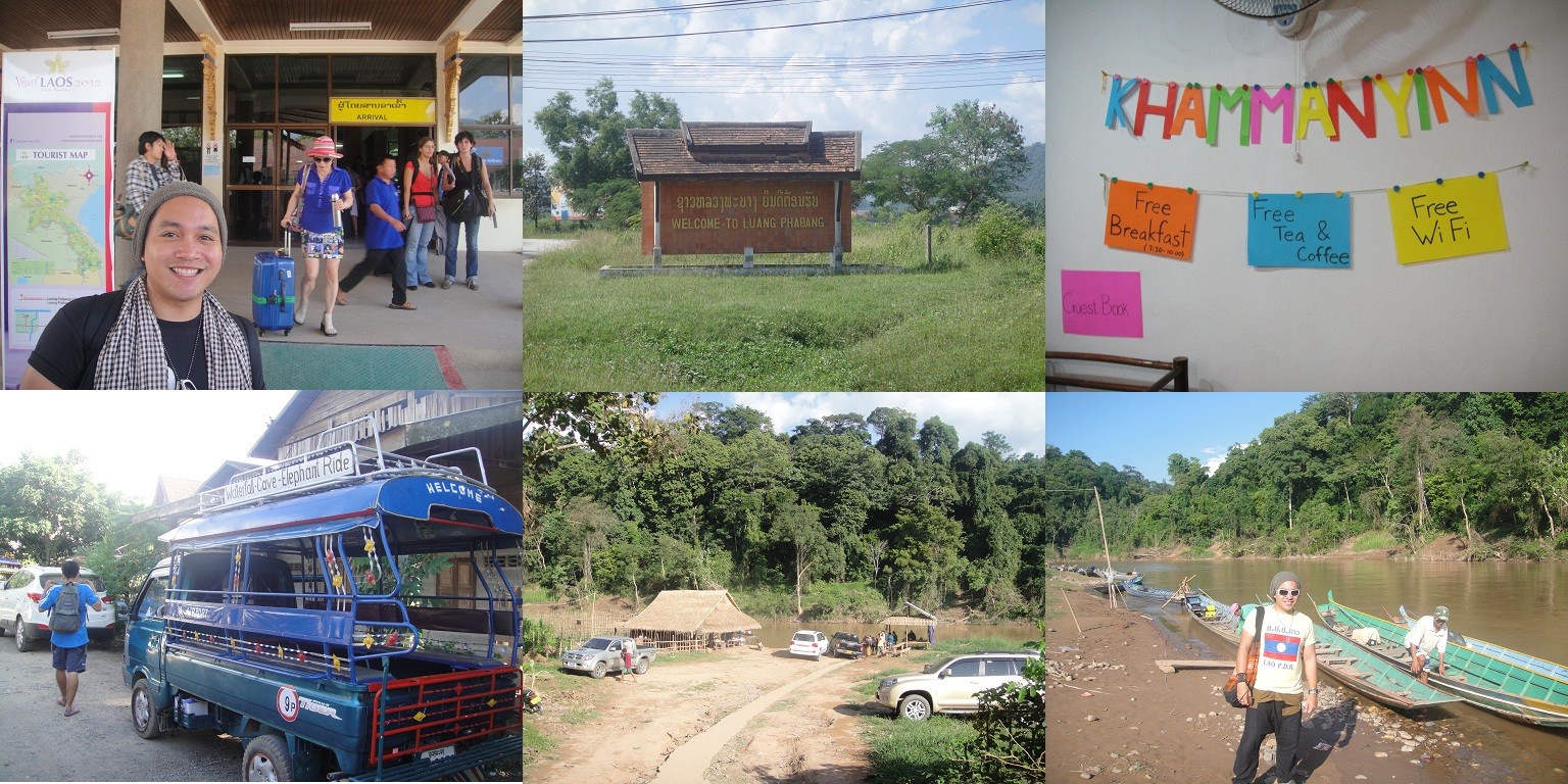
We arrived at the Khammany Inn around 11AM and I was glad they let us check in earlier than the usual 2PM check-in time, which gave us some time to freshen ourselves up and go to our destination that day. We decided to visit the popular Tad Sae Waterfalls. We had the hostel contact a tuktuk driver to bring us to Tad Sae and after some haggling and begging for a discount, we were on our way. It took us about 45 minutes to arrive at Ban Aen, a peaceful Lao village that’s just about a kilometer away from the center of Luang Prabang. Our driver dropped us at the car park and instructed us to walk ahead and so we did. We then reached the river where there were a number of boats available to take us to Tad Sae. The boat ride to Tade Sae was just quick, about seven minutes and once we got there, we paid the entrance and went ahead to explore the place.

tadsae1

I was seriously not prepared as to how BEAUTIFUL that place was! The waterfalls were so beautiful I felt like I was inside a postcard. My biggest regret that time was that I did not bring any extra clothes with me and I really, really wanted to swim there. My intention was just to take some snapshots of the place and silly me wore some pants and a pair of rubber shoes. Sorry, I was lacking some sleep and it definitely affected my train of thought that time. Thinking about it is still pissing me off. My brother ended up swimming there instead.

tadsae2

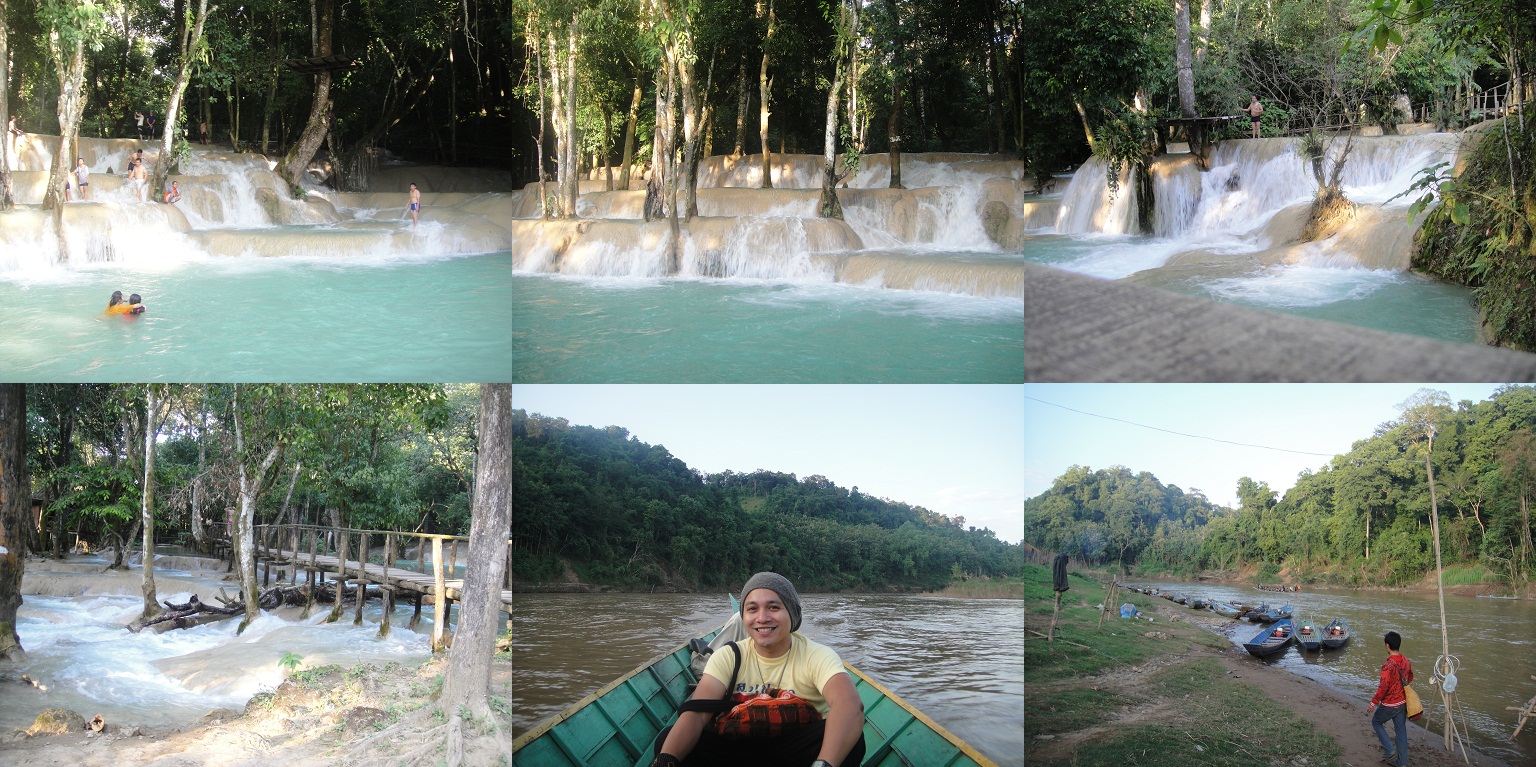
Unlike the usual waterfalls, Tad Sae Waterfalls features a wide, multi-level cascade pools of waterfalls and there is no single long-drop centerpiece (like the ones we are used to). The place is divided between the swimming area and the elephant ride area. We didn’t get the chance to see and visit the elephant area since we were enjoying the beauty of the waterfalls and my brother was having a great time swimming there. The place is perfect for a weekend getaway but we were there for just a quick stop, probably about a couple of hours only since we had to drive back all the way to Luang Prabang after that. I was surprised to see that there were not a lot of tourists visiting the place. I think I only saw two of them there aside from us. Most of the people visiting are actually locals or coming from the other provinces. We had a great time enjoying the waterfalls that our boat driver had to come and get us to inform us that we needed to go since the area is going to be closing already (that was around 5PM). We took the same boat ride back to the Ban Aen village and walked back to our tuktuk driver who was waiting for us to drive us back to the hostel.

nmkt

After freshening up (it was already around 7PM), we decided to walk around the place to familiarize ourselve with the area. We ended up at the popular Luang Prabang Night Market located on Sisavangvong Road. The food stalls that welcomes you as you enter the night market is one of my favorite parts there. I had a great time chomping and munching on the food choices available while walking around the market area, trying to shop for some souvenirs. What I really liked about Laos is the fact that their hawkers and vendors there are very pleasant to deal with and definitely not as pushy as those in Bangkok, Hong Kong and even in Cambodia. And this is seriously the cheapest of them all. I told myself that I shouldn’t buy so many stuff since we still have another day there but I ended up buying a lot of stuff anyway. I just couldn’t resist the cool t-shirt designs and those fisherman pants and all the cute knick-knacks they have there. The fact that they’re so cheap added fuel to the fire. The market closes around 10PM, so we walked back to the hostel to get some rest before exploring the city again the next day.

The Peaceful Calm of Vientiane

Posted: December 30, 2012 in Lakwatsa, Laos, Vientiane

Our flight to Vientiane was scheduled late in the afternoon, around 6PM and we arrived in Wattay International Airport at around 8PM already. Laos is probably one of the most underrated countries in Asia and also one of the most peaceful. Immigration was a breeze and their airport was small but very nice. We took a taxi to bring us to our hotel, which was the Seng Lao Hotel, located in the city center. Seng Lao was formerly a popular movie theatre in the 70s before it was converted into a 16-bedrooms, 4 stories walk-up hotel in 2007. As always, location is one of the most important reasons when I choose a hotel to stay every time I travel. After checking in, we decided to have dinner, and since it was almost 10PM already when we arrived, some of the restaurants are already closed, so we ended up eating in one of the bars a few blocks from the hotel. One thing that I was not prepared for during that time was that despite the fact that there are a number of Western foreigners in the area, a lot of the people there cannot speak any English. I was really surprised considering we didn’t have any issue at all when we were in Cambodia. So unlike being in China, where a lot of the people also do not speak any English, I didn’t have anything with me to interpret or relay what I am actually trying to tell the waitress in the bar. Sheesh. So I ended eating some vegetable meal and a Coke.

vt1

After dinner we decided to walk around the area to familiarize ourselves with the place before exploring it the next day. Vientiane is such a quiet city, that it takes you into a different kind of environment. It’s like a silent metropolitan, an exact opposite of all the overcrowded tourist destinations I have been to before. We went back to our hotel to get some sleep and to explore the place the next day.

vt2

We were there for just 2 nights in Vietiane so we have to make the most out of it. It was recommended by other bloggers to make it a short trip since the place is so small and you can go around it in just one day. Our first stop the day after was to visit the Xieng Khuan Buddha Park. Since it is located about an hour and a half away from Vientiane, we decided to look around for a driver to bring us there. Good thing I had with me my handy Lonely Planet guidebook and I realized that on the last pages of the book, there’s a summary of some of Lao words that would come in handy during traveling. I knew I had to exchange some money so I just pointed on the book the word “money” to one of the girls selling some soup and she just pointed to the direction of the bank with an ATM. After withdrawing from the ATM, I tried to talk to some tuktuk drivers to see if they can bring us to the Xieng Khuan Buddha Park. Unfortunately, about three of them cannot speak any English. I tried to just point the line on the guidebook “Do you speak English?” in Lao characters and they called one of the drivers on the other side of the street. Thank God that guy knew how to speak English. So we negotiated the price and after some haggling, we were on our way to Xieng Khuan.

buddhapark

Vientiane is hot. Like seriously hot. And the ride to Xieng Khuan was just as tolerable. The roads were a little bumpy but it was okay. Had a great time taking pictures, as always. We arrived in Xieng Khuan after about an hour and a half. The Xieng Khuan Buddha Park is a sculpture park in a meadow by the Mekong River. Although it’s not a temple, the park contains numerous religious images and contains over 200 Hindu and Buddhist statues. One notable sculpture resembles a giant pumpkin. It has three stories representing three levels – Hell, Earth and Heaven. Visitors can enter through an opening which is a mouth of a 3-metre-tall demon head and climb staircases from hell to heaven. Each story contains sculptures depicting the level. At the top, there is a vantage point where the entire park is visible. Another sculpture, an enormous 120-metre-long reclining Buddha, is also a park attraction. Despite the crazy heat, it was definitely one of my favorite places to visit and a great place for a number of photo-ops. We were there for about an hour and decided to return to our driver to drive us back to our hotel in Vientiane.

ptx1

Since it was soooooooooo hot by the time we arrived in Vientiane (around 1PM), we decided to cool off and rest inside our hotel room. We decided to go out and explore the city around 3:30PM, when the heat of the sun’s not that strong anymore. I was able to buy a bunch of souvenir t-shirts along the way. Really good quality shirts being sold at around P50 (think Penshoppe quality at that price!). Our destination that time was the Patuxai, one of Vientiane’s most popular attractions. We walked all the way from our hotel to the Patuxai, for about twenty minutes. It was not hard finding the place since I have a map with me and the city’s pretty small.

ptx2

Reminiscent of the Arc de Triomphe in Paris, the Patuxai is Vientiane’s most prominent monument. But unlike its Parisian namesake the Patuxai boasts four, rather than two, archways. The Patuxai is dedicated to those who fought in the struggle for independence from France. It may not be as huge as the Arc de Triomphe, but Patuxai on its own, is very beautiful. From a distance, it looks much like its French source of inspiration. Up close, however, the Lao design is revealed. The bas-relief on the sides and the temple-like ornamentation along the top and cornices are typically Lao. A stairway leads through two levels stuffed with souvenir T-shirts, like thousands of them, and I was there a long time haggling and trying to find the best designs and color to match my style preference. After that, I went ahead to the top of the building to catch the amazing views of the city and take a whole lot of pictures.

As Vientiane’s most popular park, the work in recent years has transformed the surrounding field to be very attractive to both locals and tourists alike and has become a good place to hang out and to soak up the atmosphere of modern Laos, with the Chinese-donated fountain complementing the entire area and making it an absolute postcard moment for everyone who visited the place.

ptl

Straight down the highway from Patuxai was our next stop, which was the Pha That Luang. Considered to be the most important national monument in Laos, Pha That Luang is a symbol of both the Buddhist religion and Lao sovereignty. The monument itself looks almost like a gilded missile cluster from a distance. Surrounding it is a high-walled cloister with tiny windows and even more aggressive-looking than the thick walls are the pointed stupas themselves, which are built in three levels. The area around Pha That Luang is now gated, to keep traffic out. Previously visitors could drive around the whole complex. We were there for some time since we waited for the sun to set and for the stupas and the temples around it to light up. The weather cooled down already and we had a good time exploring the place. It was so serene and quiet, no noisy tourists around, just some kids playing, monks walking around and a number of locals just hanging around the area.

nmkt

On our way back we passed by a night market and we decided to try some of street food that they were selling. My brother bought some fruits while I ended up munching on a pizza pie, which for me, was probably one of the most delicious pizza pies I have ever eaten in my life. Seriously. We also had dinner in one of the local restaurants along the way. Everything just seems to be so cheap in Laos that I was loving every moment of it. We passed by the Patuxai again, and just like the Pha That Luang, the place looks so good at night. I had blast snapping away pictures of every possible angle I can get out of that monument.

ptxnt

We arrived back into our hotel around 10PM, packed our stuff and decided to get some sleep since we have to leave the next day for Luang Prabang. Vientiane may be considered as a boring place but that whole day we spent walking around the area is definitely one the highlights of this trip to Laos and I loved every moment of it. Too bad we had to leave the next day but I would love to visit this place again for some stress-free vacay the next time around.

Our driver from the day before was supposed to pick us up and bring us to the S-21 Prison before leaving for our flight to Vientiane, Laos, but since he was busy, he just referred a friend of his to take us there. We had breakfast there on Velkommen, which actually doubles also as a restaurant bar, packed all our stuff and checked out early and waited for the driver to pick us up. Since we were on a time crunch that day (our flight to Vientiane was scheduled to leave at 5PM), we decided to check out early and bring all our stuff with us to save some time instead of going back there again.

ppx

Velkommen Guesthouse is conveniently located in the Phnom Penh city center and is pretty much accessible to many touristy areas there. Our first stop was Wat Phnom, which was actually just a few minutes’ walk from the guesthouse. We could’ve just easily explored it earlier ourselves, but with the pressure of having such a limited time to roam around (add the fact that there’s just too many people crowding in Phnom Penh), stopping by along the way to S-21 was a good idea.

ppx1

Wat Phnom is a hilltop sanctuary from which the capital city got its name, is one of the principal pleasure spots for the inhabitants of Phnom Penh. There weren’t that many tourists there at all when we got there, and the place was not that big so we were able to circle the place for around 30 minutes. Nothing’s much to say about this place, really. Maybe it’s because of the fact that I am just too tired of seeing all these temples ever since I left Siem Reap. The only difference was that this temple and its designs were colored salmon pink.

centralmkt

We returned back to our driver and since we still have some time, we decided to go to the Central Market to do some shopping (one of my favorite moments in Cambodia). Psar Thmei, or The Central Market, is a large market constructed in 1937 in the shape of a dome with four arms branching out into vast hallways with countless stalls of goods. The four wings of this gigantic yellow dome are teeming with stalls that sell goods ranging from gold and silver, antique coins, money exchange, men’s and women’s apparel, clocks, books, flowers, food, fabrics, shoes, souvenirs, luggage, and countless other products. I was able to buy myself a bunch of T-shirts (they were really cheap and the quality’s really good) and some ref magnets.

s21a

After that we then went ahead to our last stop, the highlight for that day, which was the S-21 Prison (also known as the Toul Sleng Genocide Museum). Originally the Tuol Svay High School, from 1975 to 1979, the Tuol Sleng Genocide Musem was the notorious Khmer Rouge prison known as S-21, through whose gates 17,000 to 20,000 people passed to their death. S-21 was an interrogation center particularly for the educated and elite : doctors, teachers, military personnel and government officials all passed through the Khmer Rouge hands. The regime was indescriminate in its choice of victims, even children, some of whom were just babies, were among those detained here and subsequently slaughtered. They were repeatedly tortured and coerced into naming family members and close associates, who were in turn arrested, tortured and killed. Prisoners’ families were often brought en masse to be interrogated and later executed at the Choeung Ek extermination center, also known as the Killing Fields, which we visited the day before.

s21b

Although the compound is surrounded by high walls and ringed by barbed wire, it’s still difficult to understand that this was once a torture center. Up to 1500 prisoners were housed here at any one time, either confined in tiny cells or chained to the floor in the former classrooms. Some of the balconies, specifically on the upper floors, are still enclosed with wire mesh to prevent the prisoners jumping to a premature death. Some cells still contain iron bedsteads to which inmates were shackled. When the Vietnamese army entered the prison in 1979, they found just seven prisoners alive; the corpses of some prisoners who had died shortly before they were discovered in the cells were buried in graves in the courtyard. It was definitely such an eerie feeling walking around that place. The fact that thousands of people were tortured and slaughtered here (there were still some blood stains on the walls and on the floors), was seriously freaky. I had to bring my rosary with me because thoughts of ghosts were going through my head. The Cambodian government really did a good job preserving this historical site and to educate everyone, locals and tourists alike, of what the country and its people had to go through a few decades ago from the hands of these soulless monsters.

s21c

There was also a display of thousands of black and white photographs of the victims, their eyes expressing a variety of emptions, from fear through defiance to emptiness, each of them holding a number. The Khmer Rouge was meticulous in documenting its prisoners. Although the majority murdered here were Cambodians, foreigners, both Western and Asian, were also interrogated and tortured.

s21d

Things get no easier emotionally after the photographic display, as you progress to a display detailing the methods of torture practised here, some of which are graphically depicted in paintings by one of the survivors. I was also able to read through some extracts in the exhibition area from forced confessions from some of the prisoners and the exchange of letters between the cadres, who sadistically continued to victimize prisoners until their declarations conformed to the guards’ own version of the truth. Reading through the torture process these prisoners had to go through makes me wonder how these monsters could even sleep at night. It was so disturbing and it was making me sick. Painting of babies being killed and tortured with the tagline “smashing babies” made it even worse for me to absorb everything that happened there.

s21e

We spent about three hours circling around the place, covering every classroom in all the four buildings. One of the three remaining survivors was also there, signing his book that details his experience in this hellhole, and having his picture taken with the tourists who visited the place. It was such an experience for me to finally arrive and walk around this place. I have always been intrigued with the Killing Fields and the S-21 Prison to finally visit this place was all worth it. I still get shivers every time I go through all the pictures I took from the place and every time I think about what those prisoners had to go through and trying to understand why the Khmer Rouge had to do this to their fellow countrymen.

s21f

Our driver was waiting for us outside and though we had a few more hours to spend, we decided to be brought to the airport instead. I originally thought of visiting the Royal Palace but since the body of the king that arrived a couple of days before was there, the palace was closed to the public. We arrived around 1PM in the airport and we stayed there for a couple of hours before checking in for our late afternoon flight to Vientiane, Laos.

Woke up early around 7AM to have some breakfast and to settle our bill at the guesthouse before leaving for the airport to catch our flight to Phnom Penh. I was very happy when I found out that the Buo Savvy gave us a discount of 10% since we stayed there for three days. The fact that its already very cheap and reasonable plus additional discounts made me one very satisfied customer. We had Sookie drive us to the Siem Reap International Airport and wait for our flight there. The two terminals, international and domestic was just beside each other. There weren’t that much passengers on the domestic terminal since most people who go to Cambodia usually travel via bus and the plane tickets are not that cheap. But I’m all about comfort so instead of enduring a 6-hour bus ride to Phnom Penh, which I was scared of, by the way, I decided to go fly instead.

pp

We flew via Cambodia Angkor Air and it took us about 50 minutes to get to Phnom Penh. I had book us an overnight stay on Velkommen Guesthouse and had requested to be picked up at the airport. This time, it was not a tuktuk waiting for us, but a taxi. Though there were tuktuks everywhere as well. There was some traffic but it was okay. At least it was not the day before when the king’s body arrived, otherwise, we’re screwed. I had planned for us to visit the Killing Fields, which was just a few minutes from the hotel and to visit the S-21 Prison the next day before leaving for Laos in the afternoon. Talk about a major timecrunch. How I was able to squeeze all of it in is such an achievement for me! Haha!

pp2

Once we arrived at the Velkommen Guesthouse, which was around 11AM, we just left our luggage and our stuff in their storage room and had our taxi driver bring us to the Killing Fields. Choeung Ek, or popularly knows as the Killing Fields of Cambodia, is the site of a former orchard and Chinese graveyard about 17 km south of Phnom Penh. It is the best-known of the sites known as The Killing Fields, where the Khmer Rouge regime executed over one million people between 1975 and 1979. Mass graves containing 8,895 bodies were discovered at Choeung Ek after the fall of the Khmer Rouge regime. Many of the dead were former political prisoners who were kept by the Khmer Rouge in their Tuol Sleng detention center.

pp3

Today, Choeung Ek is a memorial, marked by a Buddhist stupa. The stupa has acrylic glass sides and is filled with more than 5,000 human skulls. Some of the lower levels are opened during the day so that the skulls can be seen directly. Apart from the stupa, there are pits from which the bodies were exhumed. Human bones still litter the site. Though a little disturbing at first, I appreciate the fact that the Cambodian government decided to preserve and to not disturb the remains still present in the fields. Clothes of the actual victims, some of them children, are being preserved and displayed and it felt a little eerie walking around the place. There was an audioguide available together with the ticket and it was such a learning experience for me as I walk along the entire area and just to listen to the narrations of what these innocent people had to go to at the hands of these monsters is just sickening. We were there for about two and half hours and had our driver bring us back to our guesthouse to settle in. I was pretty tired from too much travelling and lack of sleep that after having dinner and a quick walk in Sisowath Quay, I decided to retreat back to the guesthouse and get some sleep.

Our third day was our last day in Siem Reap and it seemed like we were able to cover most of the Angkor temples. We decided to visit one of the farther temples, Banteay Srei, which lies near the hill of Phnom Dei and about 16 miles from the main Angkor temple area. Built at a time when the Khmer empire was gaining significant power and territory, the temple was constructed under the rule of Rajendravarman. The temple’s relatively small size, pink sandstone construction and ornate design give it a fairyland ambiance.

bs

Given that it’s a little farther from the city center, we decided to visit one more temple after Banteay Srei, which was the Banteay Samre. Located east of the East Baray, Banteay Samre is a Hindu temple in the Angkor Wat style, and uses the same materials as Banteay Srei. Constructed around the same time as the Angkor Wat, the style of the towers and balustrades bear strong resemblance to the towers of the Angkor Wat. The place was a bit bigger than Banteay Srei and we spent about an hour and a half around the place before leaving for our last stop, which was the Tonle Sap Lake. At that point, I’ve just had enough of the temples that I was about to puke.

bs2

Known as the largest freshwater lake in South East Asia and is an ecological hot spot that was designated as a UNESCO biosphere in 1997, the TonlĂ© Sap is a combined lake and river system of major importance to Cambodia. Nothing’s really that great about the lake, in my opinion. It was nice to see some of the locals do their daily routines around the lake and water villages, but it was very much similar to those in Brunei, except maybe there were no mosques around. Plus it was so freaking hot but I guess we needed that time to get away from all those temples. We were there for about an hour and a half and had Sookie drive us back to our guesthouse.

bs3

We arrived back around 6PM since we had to pack our stuff to leave for our flight to Phnom Penh the next day. During that day, news of the former king of Cambodia died in China and the TV screens everywhere featured just that. I guess he was really loved by his people. The body of former Cambodian King Norodum Sihanouk was scheduled to arrive in Phnom Penh from Beijing the next day and I got a little worried since we saw on TV that the streets of Phnom Penh covered with locals, monks, policemen and news reporters everywhere. We were there overnight only and I got a little worried that its gonna screw up our Phnom Penh itinerary the next day.

For our second day in Siem Rep, I have outlined the temples we were to visit using the map from the guidebook that our driver, Sookie, gave us. We decided to check out those that are nearby and decided to visit one of the farther temples the day after instead.

bk1

We started by visiting Banteay Kdei first. Since Srah Srang, a picturesque baray opposite the entrance of Banteay Kdei was nearby, we took some photo-ops there before entering into Banteay Kdei. There were a number of very pushy children there selling souvenirs and they were pretty cute and could speak really fluent English. I was really surprised since the English words that they were using, though having an accent, are a bit more mature than what normal children their age would be using. I was able to buy a bunch of bracelets, magnets, t-shirts and I finally got myself a krama, a sturdy traditional Cambodian garment that is popular for being used as a scarf or a bandanna.

bk2

After that, we then went to Banteay Kdei. Known as a “Citadel of Monks’ cells”, Banteay Kdei is a Buddhist temple in Angkor, Cambodia. Built in the mid 12th to early 13th centuries AD during the reign of Jayavarman VII, it is in the Bayon architectural style, similar in plan to Ta Prohm and Preah Khan, but less complex and smaller. Its structures are contained within two successive enclosure walls, and consist of two concentric galleries from which emerge towers, preceded to the east by a cloister. We were there for about an hour since the place was not that big.

bk3

Our next temple stop was Pre Rup, whose name is a comparatively modern one meaning “turn the body”. This reflects the common belief among Cambodians that funerals were conducted at the temple, with the ashes of the body being ritually rotated in different directions as the service progressed. Historically important in that it was the second temple built after the Khmer capital was returned to Angkor after a period of political upheaval. Less than a decade earlier, the artistically similar East Mebon, which we also passed by, was the first to be constructed after the return to Angkor. Okay, with just way too many pictures taken and too many temples visited, forgive if I am getting all these pics mixed up hehe.

bk4

After circling the entire place, it started to rain a little. We headed to our next stops, which were Neak Pean and Preah Khan. A small island temple located in the middle of the Preah Khan baray, Neak Pean’s central temple sits at the axis of a cross or lotus pattern of eight pools. It took its name from the encoiled nagas that encircle the temple. Since it rained so hard already when we arrived, we didn’t get to take much pictures there. Funny coz it actually did stop raining when we left the place and when we arrived in Preah Khan. Were the gods trying to tell us something? I feel it’s definitely good luck. Normally, the pool that surrounds the small island and the temple is empty but when we were there, the pool was very full because of all the rainfall that’s happening. I had to make sure all my stuff were dry (good thing I had them zip-locked) coz I only had a small umbrella with me and I had to share it with my brother.

bk5

Preah Khan was just a few minutes’ drive from Neak Pean. A huge, highly explorable monastic complex full of cavings, passages and photo opportunities, Preah Khan originally served as a Buddhist monastery and school, engaging over 1000 monks. In harmony witht he architecturally similar Ta Phrom, which was dedicated to Jayavarman VII’s mother, Preah Khan is dedicated to his father. The temple is flat in design, with a basic plan of successive rectangular galleries around a Buddhist sanctuary complicated by Hindu satellite temples and numerous later additions. Like the nearby Ta Prohm, Preah Khan has been left largely unrestored, with numerous trees and other vegetation growing among the ruins. We were there for about an hour and a half, then we decided to return back to the guesthouse for some much needed rest.

Going to Cambodia has always been on my bucket list for some time now. I’ve always wanted to visit the Angkor temples and check out the Killing Fields. The fact that they’re located in separate cities did not help as well. So I told myself, what the hell, if I wanted to be there, might as well check them all out. Ever since Cebu Pacific started offering direct flights to Siem Reap from Manila, I was always on the look out for the seat sale to come in. I am usually lucky in booking really cheap flights but for this one, the only way I can get a cheap round trip ticket was to book for a flight scheduled within eleven days. So that’s when the idea to visit Laos came in. I’ve always been intrigued by the so-called charm Laos has to offer so I decided to book those tickets to fly to Siem Rep and squeeze in Laos as well.

sr1

Trying to accomplish a fool-proof itinerary to visit two cities in two countries in eleven days was my goal and yeah, I guess I survived. Now, since I don’t travel solo and I needed someone to be my cameraman, I invited my brother to tag along. And plus, it was also my birthday gift to him. Though I really needed someone to take my pictures. LOL!

sr2

I booked us to stay at the Bou Savvy Guesthouse, based on recommendations from other bloggers and the really good feedbacks I have read about them online. We arrived around 9PM in Siem Reap and had them pick us up in definitely one of my most favorite tuk-tuks in Asia. It was one of my favorite tuktuks, cushioned with pillows to match. Cambodia sure beats Thailand and the other Asian countries in terms of this. Our driver that time, named Sookie, also ended up as our driver/tour guide for the rest of our stay in Siem Reap. Once we arrived at the cozy guesthouse, about twenty minutes from the airport, we checked in and planned our itinerary for the next few days. Sookie handed us the Siem Reap Visitor’s Guide book complete with maps of temples and the must-see places in Siem Reap, which made it easy for me to plan out our itinerary then and there. Though I had planned our itinerary a week before, having that handy guidebook made it easy for me to squeeze in some more temples and make some adjustments. After finalizing our plans for the next three days, my brother and I went into our room to get some rest and get ready for the next day ahead.

sr3

We had breakfast the next day in our guesthouse before leaving for the Angkor temples. Sookie was waiting for us at exactly 8AM and he brought us to buy some temple tickets, which was a requirement for every tourist who plans to visit the temples scattered all over Siem Reap. We took the three-day temple pass which was priced for $40. We even had our pictures taken for the ticket to ensure that it’s being used exclusively and will not be shared with anyone else.

sr4

After buying our tickets, we made our way to the southern gate of Angkor Thom. Every entrance has a checkpoint, so presenting our tickets with our pictures on it was necessary before entering the Angkor gates. The last and most enduring capital city of the Khmer empire, Angkor Thom covers an area of 9 km², within which are located several monuments from earlier eras as well as those established by King Jayavarman VII and his successors. Angkor Thom is in the Bayon style. This manifests itself in the large scale of the construction, in the widespread use of laterite, in the face-towers at each of the entrances to the city and in the naga-carrying giant figures which accompany each of the towers. Some of the scenes from the movie Lara Croft: Tomb Raider was shot here as well. From the south gate of Angkor Thom, Sookie drove us all the way through the forest to the majestic Bayon. He then dropped us off at the main approach, from the east, and instructed us that he will just around to the north and wait for us there in the Terrace of the Leper King area. Angkor is huuuuuuuuge. We spent around 3 hours alone in the Bayon area and I have never seen a place where every step would just lead into a photo opportunity. Though I’ve seen temples all my life, nothing beats the beauty of the Angkor temples.

sr5

One of the must-see temples in Cambodia, aside from the very popular Angkor Wat, the Bayon is a richly decorated Khmer temple, with giant stone faces that has become one of the most recognizable images connected to classic Khmer art and architecture. This place alone is really huge. There are 37 standing towers, featuring the multitude of serene and massive stone faces on the many towers which jut out from the upper terrace and cluster around its central peak.

The best of Bayon are the bas-reliefs on the exterior walls of the lower level and on the upper level where the stone faces reside. The bas-reliefs on the southern wall contains real-life scenes from the historical sea battle between the Khmer and the Cham. Even more interesting are extensive carvings of unique and revealing scenes of everyday life that are interspersed among the battle scenes, including market scenes, chess games and childbirth. Some of the carvings on the walls were said to be unfinished, likely indicating the death of Jayavarman VII and the subsequent end of his building campaign.

sr6

We continued our walk to the rest of the temples in the Angkor Archaeological area, passing and stopping by Baphuon for some additional photo-ops as well. Recently reopened after an extensie and troubled restoration, Baphuon is a large temple-mountain in Angkor Thom, located just a few steps northwest from the Bayon. Built in the mid-11th century, it is a three-tiered temple mountain built as the state temple of Udayadityavarman II dedicated to the Hindu God Shiva. Along the way we passed also passed by the Terrace of the Elephants, a fabulous bas-relief frieze of near-life sized elephants stretching some 300m. The elephants are shown in profile, mostly hunting, though some are depicted fighting with tigers.

sr7

Adjoining the Terrace of the Elephants, the Terrace of the Leper King is a double terrace wall with deeply carved nagas, demons and other mythological beings. The terrace was named for the statue of the Leper King that sits on top. Sookie was waiting for us there to bring us to our next stop, which was the Ta Phrom. We decided to have lunch first along the way, and one negative thing about it was that, it takes them soooooooo long to prepare a meal! We waited for almost an hour inside that restaurant before they served us our orders, and it was the same thing as well with the next few days we have in Siem Reap. We should’ve just brought our own food if we had known it would take them that long to prepare it.

sr8

After lunch, we were on our way to Ta Phrom. One of my favorite temples, mainly because it has been very much featured in the Tomb Raider movie, the Ta Phrom, built in the Bayon style largely in the late 12th and early 13th centuries and originally called Rajavihara, it is located approximately one kilometre east of Angkor Thom and on the southern edge of the East Baray, it was founded by the Khmer King Jayavarman VII as a Mahayana Buddhist monastery and university. Enormous kapok trees grow from the terraces and walls at Ta Phrom, their massive roots clinging to the walls, framing doorways and forcing open giant stones apart. Ta Phrom was one of the bigger temples in the area and we were there for about a couple of hours, I think. I wasn’t able to resist posing against those trees which crawl over the north side of the second enclosure. The background of those trees mixed with the temple walls is just amazing.

sr9

Our last and final stop for that afternoon was the visually, architecturally and artistically breathtaking Angkor Wat. Known to be the largest Hindu complex and the largest religious monument in the world, the Angkor Wat is a massive three-tiered pyramid crowned by five lotus-like towers. It is the centerpiece of any visit to the temples of Angkor. Constructed in the form of a massive temple-mountain dedicated to the Hindu god, Vishnu, it served as Suryavarman II’s state temple. Other than the topmost level of the complex, the most important thing to see at Angkor Wat is the gallery of remarkably detailed bas- reliefs carved into the third enclosing wall, relating tales from Hindu mythology and a military procession led by Suryavarman II.

sr9a

As the best-preserved temple at the site, it is the only one to have remained a significant religious centre since its foundation – first Hindu, dedicated to the god Vishnu, then Buddhist. The temple is at the top of the high classical style of Khmer architecture. It has become a symbol of Cambodia,appearing on its national flag, and it is the country’s prime attraction for visitors.

sr9b

We were there in the Angkor Wat for a couple and a half hours and it was literally photo clicks every step of the way. There were so many photo-ops inside the temple that I didn’t want to leave. Sookie, our driver, was waiting for us so we had to go, but we were able to circle around much of the temple before we left. We arrived back at the guesthouse around 6PM and we contracted Sookie to pick us up later around 8PM to bring us to the popular Pub Street, Siem Reap’s popular hang out spot lined with restaurants and bars. We had dinner in one of those Happy Pizza restaurants, known for putting a special ingredient on their pizzas, which was the marijuana. Pub Street was not that big, so after shopping for some souvenirs, we met up with Sookie to bring us back to our guesthouse to get some sleep and prepare for the next day ahead.

Since we were only to stay in Jeju for two days, we knew we had to make the most out of it. The day before, we had the hostel contact a driver for us to drive us around Jeju Island for eight hours, listing down all the places we wanted to go to and map out an itinerary for us. We woke up around 8AM and got ready since the driver will be picking us up by 9AM. We skipped breakfast and instead bought some snacks and sandwiches on the nearest convenience store and just ate along the way.

Our first stop was the Jeju Stone Park. An ecological and cultural park that displays the history of stone culture pivotal to the history and culture of Jeju Island, the Jeju Stone Park covers a wide variety of exhibitions in a large area. Befitting the unique natural landscape on Jeju Island, the park is situated nearby oreum small volcanic cones scattered throughout the island. Visitors can arrive at the entrance of the park by walking along what looks like fortress walls on a gentle hill. Our driver was able to convince the girl from the ticketing counter to let us enter for free since we were there for about 45 minutes only, which actually lasted for about an hour and fifteen minutes.

Had a great time doing some quick photo-ops and the fact that there were not a lot of visitors during that time, we did enjoy walking around the place and taking snapshots of just about every stone sculpture we passed by. From sculpture of the Grandmother Seolmundae and the Five Hundred Generals, there were also traditional local hatched-roof houses amidst the forest. Overall, surrounded by beautiful nature, the park offers the unique culture and history of Jeju Island.

Our next stop was the Manjanggul Lava Tube. A UNESCO World Heritage Site, the Manjanggul Cave is one of the finest lava tunnels in the world, and is a designated natural monument. A lava tunnel is formed when the lava that was deep in the ground spouts from the peak and flows to the surface. Manjanggul Cave has a variety of interesting structures inside including 70cm lava stalagmites and the lava tube tunnels. It is regarded as having significant scientific and heritage value, owing to its excellent condition of preservation despite its age of formation. It was pretty dark, slippery and cold inside the cave, and I think they needed to place more lighting there. I was kinda frustrated with the shots I had since it was so dark and due to the lack of lighting, didn’t get to take as much beautiful photos that I wanted.

We had lunch afterwards in one of the restaurants along the way and enjoyed my favorite bibimbap. We then went ahead to visit the Seongeup Folk Village. Located at the foot of Mt. Halla on Jeju Island, Seongeup Folk Village is a small town that holds a vast amount of culture. The Seongeup Folk Village shows the unique culture of Jeju Island: the black lava rock walls, the straight but curvy alleys to block the wind, and the stone grandfather statues known as the Harubang, which have become a prime feature of the landscape.

Our next stop was one of the highlights of the day, visiting the Seongsan Ilchubong Peak. Located near the eastern town of Songsan-ri, the Seongsan Ilchubong Peak is the easternmost tip of Jeju Island. This area is the first to greet each day’s new sun, thus earning the name of “Sunrise Peak.”

Definitely one of my favorite spots in Jeju, the Seongsan Ilchubong is the famous round almost-island you’ll see pictures of everywhere in Jeju. A 180m high tuff volcano, it was one of the toughest climbs of my life, but reaching the top of the peak after about thirty minutes and about 600 steps later was all worth it. There are numerous hydromagmatic volcanoes similar to the Seongsan Ilchubong, but there are no other known hydromagmatic volcanoes with a well-preserved tuff cone and diverse internal structures along a sea cliff. Because of these scientific values and remarkable scenery, Seongsan Ilchubong Tuff Cone was able to be designated as a UNESCO World Natural Heritage site and it is worth preserving permanently as a natural heritage of humankind.

On our way to our next stop, which was the Cheonjeyeon Falls, we were able to pass by the beautiful Saeyeon Bridge, the bridge that connect Seogwipo Harbor and Saesom Bird Island. I would’ve loved to stay there and take in the beautiful scenery but we were on a time-crunch. We also passed by Yakcheonsa Temple, one of Korea’s Buddhist temples and reminiscent of that of Buddhist temples of the early Joseon Dynasty. And since I’ve had enough of temples already all my life, a quick photo-op was enough for me and then we were on our way to Cheonjeyeon Falls.

We got a little confused communicating with our driver since there were actually three popular waterfalls in Korea, and two of them were called Cheonjeyeon and Cheonjiyeon. Yes, the only difference is one letter. One is with an I and the other one is with an E. We just asked him where was the nearest one and Cheonjeyeon was nearby, so we went there instead.

A three-tier waterfall, Cheonjeyeon Waterfalls is one of the most popular tourist attactions in Jeju Island. Known as the “Pond of the Emperor of Heaven”, Cheonjeyeon Falls consists of 3 parts. The water from the first waterfall becomes the second and third waterfalls and flows into the sea.

We were on a really tight time crunch at this point since it would take about an hour or so to get back to our hostel in Jeju City and we had to catch a flight back to Gimpo. So after circling around the Cheonjeyeon area, we went back to our driver and convinced him to take us to one last stop, which was the Jusangjeolli Cliff. He was a bit hesitant at first since we actually exceeded already the hours we bought for the trip but he was kind enough to bring us to Jusangjeolli and told us we had about an hour to roam around the place and take some pictures.

The Jusangjeolli Cliffs refer to the set of blackish, rock pillars piled up along the coast and is a designated cultural monument of Jeju Island. The Jusangjeolli was formed when the lava from Mt. Hallasan erupted into the sea of Jungmun. Its 20 m cliff makes it a popular spot for high tide, sea angling. The waves of the high tides crashing into the side of the cliff provide a breathtaking view of the ocean surrounding the pillars. Most commonly expressed as vertical columnar jointing, the formations are created via sudden cooling of lava that shrinks in mass. The sight of waves crashing against the columns is both serene and beautiful.

After about an hour later, we headed back to our car and had the driver take us back to Jeju City to pack all of our stuff and head back to the airport. The driver was kind enough to wait for us while we sprinted our way to our room and packed all our stuff like crazy. We arrived about 45 minutes before our flight leaves for Gimpo. Since the AREX closes around midnight, we were just in time when we took the subway from Gimpo to Incheon for another hour and stayed there at the Incheon International Airport for our flight back to Manila scheduled at 6AM later that day.

Truly one of the best vacations I’ve ever had, and definitely the best country I have been to so far, I definitely fell in love with Korea. I wish we could’ve stayed there longer. From the food to the friendliest and most helpful people I have ever met while on a trip, this is one of the places I know I’d be coming back over and over again. There are still a lot of places to go to and visit and I just know I’m going to be back here again sooner than later.

Hearing a lot of stories about Jeju Island made me curious about it, and after seeing it online, I knew I had to go there. We never did plan to visit Jeju when we booked this trip to Korea, but after some planning, we decided that we should really squeeze it in. It’s Day 6 of our Korea trip and we woke up really early to catch our 11AM flight to Jeju Island. I had some trouble booking tickets online via Jeju Air since they only accept Korean credit cards, so we ended up with Eastarjet instead. We dragged our luggages down the streets of Hongdae to the subway station, to finally arrive on Gimpo International Airport, about an hour later, to catch our flight to Jeju Island.

Once we have finally landed in Jeju International Airport about an hour later, we took a bunch of brochures and guides, took a taxi outside, showed the taxi driver the address to our hostel in Jeju City, HKJeju Hostel, which we had one of the Korean counter girls from the Gimpo Airport translate and write in Hangul (which was a really good idea, by the way, since he cannot read or understand any English), and after about 10 minutes, finally arrived on our hostel. Check-in was scheduled for 2PM, so we decided to leave our stuff and have lunch since we were very hungry, so we decided to eat on one of the nearby restaurants just a couple of blocks from the hostel.

We headed back to the hostel around 2PM, and after cleaning up, decided to visit one of the most controversial theme parks in Korea, which was the infamous Loveland. Located on the road between Jeju City and Seogwipo, Loveland is Jeju’s most eccentric and internationally infamous attraction and almost a reason in itself to visit Jeju. Jeju Loveland is an outdoor sculpture park which opened in 2004 on Jeju Island in South Korea. The park is focused on a theme of sex, running sex education films, and featuring 140 sculptures representing humans in various sexual positions. It also has other elements such as large phallus statues, stone labia, and hands-on exhibits such as a “masturbation-cycle.” The park’s website describes the location as “a place where love oriented art and eroticism meet.”

This bizarre sex-themed sculpture park was created by graduates of Seoul’s Hongik University. Almost each and every statue and sculpture there is generally shocking and absolutely artistically pornographic (if you wanna call it that way) and it makes for some interesting holiday snaps that you won’t want to show your parents. Well, I had to, I took a pic of each and every one of them. It also has a sex shop, a souvenir shop and a restaurant filled with sex painting and portraits everywhere. What is up with Jeju and their obsession with phallic symbols?

We were there for the entire afternoon, taking pictures and snapshopts of every sculpture and just enjoying the fact that a theme park like that actually existed. Once we have covered the entire place, we decided to head back to the hostel to get some rest. We had dinner later that night and decided to taste one of the island specialties, the black pork, which was seriously delicious.

We then just walked around the area, did a bunch of photo-ops and headed to the Dongmun Market Place. Open since 1945, Dongmun is the best place to go for a taste of the local foodstuffs, like black pork, tangerines, hairtail fish, and abalone. Located at the crossroads of several olle walking trails and next to the lively Tap-dong district, it’s a great place to explore. Audrey was trying to find some kimchi to bring back home and the people were very helpful. Even though some of the stores were already closed, one of the storeowners actually called this lady, who I think was the only one selling kimchi there and told her that we wanted to buy some kimchi. I ended up buying a bunch of the popular local Jeju Orange chocolates, which was one of the island’s specialties.

Walking around Jeju City at night was a great experience. It had the artistic vibe similar to Seoul, but definitely more peaceful and more quiet. Just like Seoul, the place never ran out of photo-worthy shots and is definitely a sweet paradise of its own. We retreated back to our hostel around 10PM to prepare us for a really long day around Jeju the next day.

For our last day in Seoul, we have booked ourselves a tour to visit the Demilitarized Zone (DMZ) and Panmunjeom. I have always been curious and intrigued about the DMZ ever since I first saw it being featured on National Geographic. Known to be as the “Dangerous Divide” between the two Koreas, the Korean Demilitarized Zone is a strip of land running across the Korean Peninsula that serves as a buffer zone between North and South Korea which runs along the 38th parallel.

Our hostel recommended that we contact Cosmojin Tours to make reservations for the DMZ and Panmunjeom Tour at least a week before our desired tour date. The tours are only available from Tuesday to Friday and since we will be leaving for Jeju Island on Thursday, our only options were either Tuesday or Wednesday. We originally booked for a Tuesday tour but they informed us that there is a military training scheduled for that date, so we settled for Wednesday. We were glad that they did not require any advance payments from us, just our names and passport numbers. They also offered free pick-up from our hostel, which made it even more better.

A week before our Korea trip, I got myself a haircut. Yeah, after three years, I finally decided to chop a big chunk of my hair off. Only for the DMZ. They have a lot of strict guidelines and instructions on the site and the line “no shaggy or unkempt hair” scared me. There is also a dress code, and nobody under 11 years old is allowed on the DMZ. What really got me curious though was the list of nationalities that are not allowed to visit the Panmunjeom area (not sure if they are allowed to visit the DMZ though). This included Koreans and a bunch of other Asian countries. I think only Japan, Brunei, Laos, Cambodia and the Philippines were not listed there on the restricted nationalities that could not enter the Panmunjeom area. I think the fact that the Philippines sent about 7,000 soldies to aid South Korea during the Korean War was the main reason why Filipinos are very much welcome to visit this place. We woke up really early for this since we are being picked up at 7AM. The driver then dropped us off at the Lotte Hotel to meet up with the other tourists that are taking this tour. We settled our payment with the Cosmojin representative and in about an hour, we were on our way to Panmunjeom and to the Joint Security Area.

It took us about an hour and a half to arrive at the Panmunjeom Area. We were transferred from one bus to another, making sure that all seating arrangements assigned to us are followed. A passport check was performed when we reached the Unification Bridge, then we went ahead to Camp Bonifas. Home to the United Nations Command Security Battalion – Joint Security Area, whose primary mission was to monitor and enforce the Armistice Agreement of 1953 between North and South Korea, Camp Bonifas is where the security escorts conduct the UN Command DMZ Orientation Program tours of the JSA and surrounding areas. After receiving a detailed briefing at the JSA visitor’s center and after signing a waiver that states that the United Nations Command are not to be held accountable in the event of a hostile enemy act and the possibikity of injury or death as a direct result of enemy action (whew), we then went ahead with the tour to visit the Joint Security Area.

Before entering the Freedom House, we were assigned to form two lines and to have a partner with us. Probably the most exciting and stressful part of this tour, we went ahead inside the Freedom House and just outside the Military Armistice Commission (MAC), came face to face with North Korea. We were instructed to form two horizontal lines, facing North Korea, making sure that the one in front of us is shorter. We are only allowed to take photos of the person in front of us, with their backs to North Korea, and never the other way around. You can really feel the tension at this point. Our guide then announced that we can now go inside the MAC building. It’s this small blue mini-conference room a few steps from the Freedom House. The Military Armistice Commission has held secretary’s meetings, joint duty officer’s meetings, and general meetings for observation of the Armistice Agreement since its signing. Joint duty officer meetings can be called by either side. The Military Demarcation Line (MDL) of the Joint Security Area runs through the middle of Panmunjeom and even the meeting buildings. The line of microphone wires on the table of the conference room traces the path of the MDL. We were then reminded not to touch anything that belongs to the North, from their microphones to their flags. I will never, ever dare touch anything by the North Koreans! Haha!

Our guide then told us that we can go ahead and have our pictures taken with the South Korean soldiers standing on the North Korean side of the room. My eyes suddenly lit up and I was the first one to stand beside that soldier and had my picture taken, right there in North Korean soil. It took about a minute when our guide suddenly raised her voice and said, “Everybody get back to South Korea now!” Seriously, we were scrambling like crazy. We then went out of the MAC building, back to the Freedom House and back to our tour bus. We were dropped off at a souvenir shop and I went ahead and bought a couple of books about the Korean War. Yes, I was very, very interested about all this. I normally do not care about history stuff, but I was really curious about how this all happened.

We were scheduled to do the DMZ Tour next, so we had lunch in this restaurant in Imjingak Park. More than half of those who joined us for the Panmunjeom Tour are not taking the DMZ Tour, so there were like just 6 of us left that’ll spend the rest of the day in the area. After lunch, there was a new tour guide that joined us and he took us to this mini-museum and gave us a brief overview about the history behind the DMZ. And yes, I was paying really hard attention to every word he was saying. We then had a quick film viewing, more like snapshots about the Korean War and how the DMZ came about, and it was truly a learning experience.

We then went ahead to visit the Third Tunnel Of Aggression. The largest tunnel of the four underground tunnels dug under the DMZ by North Korea, the 3rd Tunnel is so large that an army of 30,000 fully-armed North Korean soldiers and their vehicles and weapons can pass through the tunnel in an hour. Upon discovery of the third tunnel, the United Nations Command accused North Korea of threatening the 1953 armistice agreement signed at the end of the Korean War.

Its description as a “tunnel of aggression” was given by the South, who considered it an act of aggression on the part of the North. Initially, North Korea denied building the tunnel. However, observed drill marks for dynamite in the walls point towards South Korea and the tunnel is inclined so that water drains back towards the northern side of the DMZ, and thus out of the way of continued excavation. We were instructed to leave our cameras on the lockers provided just outside the tunnel, but, well, since we won’t be coming back here again, guess who forgot to leave his camera behind? Hehehe! It was pretty cold down there and you can easily run out of breath from the long walk all the way to the blocked entrance from North Korea’s side.

After returning back to the tunnel entrance, we then went ahead to the Dora Observatory. Located on the South Korean side of the 38th parallel, the Dora Observatory is situated on top of Mount Dora, and looks across the Demilitarized Zone. It is the part of South Korea closest to the North. Visitors can catch a rare glimpse of the reclusive North Korean state through binoculars from the 500-person capacity observatory. They will be able to see the North Korean propaganda village situated in the DMZ, a remnant of the old prosperity of the North, and can see as far as the city of Kaesong. A photo line is also designated there if you would like to take pictures of North Korea, but you won’t be allowed to take any pictures once you have crossed it. A South Korean soldier had me delete some of the photos I took outside the photo line and I just pretended and acted that I did. I mean, it was just a bunch of bushes and trees anyway. Even with me using the binoculars, seriously, it was all just bushes and trees. I was hoping I’d get to see a North Korean farmer working or something.

We then went ahead to our last stop of the tour, which was the Dorasan Station. Dorasan Station is a railroad station situated on the Gyeonguiseon Line, which once connected North and South Korea and has now been restored. However, on December 1, 2008, the North Korean government closed the border crossing, after accusing South Korea of a confrontational policy. This coincided with the South Korean legislative election, 2008, and a change to a more conservative government. Plans to begin regular passenger service across the Imjin River to North Korea have yet to be finalized. However, a tourist visit in January 2010 showed clearly that the station was completely shut to all train travel, and that the station was only open for tourists. We were there for about fifteen minutes, took some photos with the ROK soldiers and went back to our bus that’ll take us all the way back to Seoul.

We were dropped off at Itaewon and we decided to just roam around the area and visit Domdaemun. Domdaemun is another shopping district in Seoul, much better than Myeongdong since it’s a larger area and there are malls open 24 hours. I find it weird though that some of the mall’s opening hours are from 10PM to 5AM. We spent the rest of the night hanging around Domdaemun, watching the locals dragging their huge shopping bags and did some last minute shopping ourselves since it’s our last day here in Seoul and we are off to Jeju Island the next day.